Trail Marker Trees

Trail Marker Trees were an ancient form of land and water navigational aids, as well as a marking system to denote areas of significant importance such as ceremonial sites. These trees were used by many, if not all, of the Native American tribes and later by fur traders and early pioneers. The Trail Marker Trees differed in their appearance and formation from tribe to tribe and from region to region. Examples of these trees have been found all across the United States and throughout Canada.

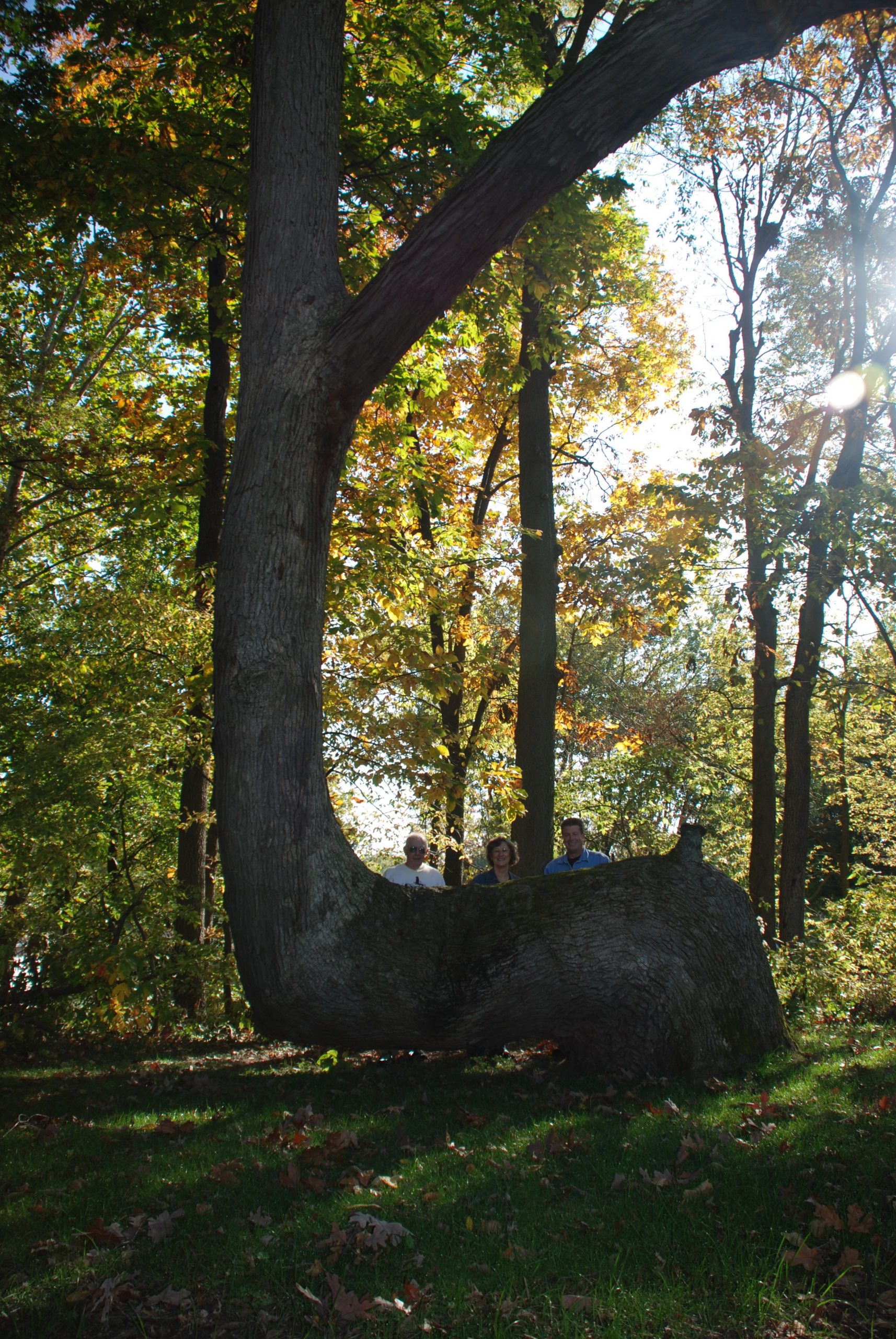
One unique characteristic of the trail marker tree is a horizontal bend several feet off the ground, which makes it visible at greater distances, even in snow. Researcher Dennis Downes was first introduced to the Trail Marker Trees as a young boy and was influenced by his own Native American relative. Mr. Downes has spent nearly thirty years of his adult life in the field locating, documenting, and educating others about these historical icons. See and read more on his website: Great Lakes Trail Marker Tree Society. There’s also a Wikipedia page on the topic.

Via Roel Roscam Abbing. Image: Trail Marker Tree in White County, IN known as ‘Grandfather’. CC BY-SA 3.0.

Sailing 10,000 Nautical Miles Using the Stars, Moon and Sun

Te-aurere-wakaA group of intrepid Māori sailors from New Zealand will take on the world’s biggest ocean, the Pacific, in an attempt to sail to Easter Island, the most remote inhabited place on Earth, without GPS, charts, maps, or even a compass.

Instead the group will be guided by the traditional techniques that helped the Polynesian people traverse the wide expanses of the Pacific and settle the islands of Hawaii, New Zealand and Tonga, to name just a few – techniques like the movement of the stars, the sun and moon, oceanic currents and bird and animal life.

The sailing odyssey is part of an effort by Polynesian academic and cultural groups to reclaim the navigational knowledge of their forebears, much of which was lost after European colonization.” Read more (official website). Previously: Polynesian stick charts / Satellite navigation in the 18th century / Developed nations dangerously over-reliant on GPS.

Developed nations dangerously over-reliant on GPS

Developed nations dangerously over-reliant on GPS

“As technologies become easier to use and more cost effective their use can become almost ubiquitous. If they present a more convenient solution to an old problem, they can usurp older technologies very quickly, forcing obsolescence on otherwise excellent technologies and taking a dominant position. The use of Global Navigation Satellite Systems (GNSS) for deriving position, navigation and timing (PNT) data is such a case. The Global Positioning System (GPS) is currently the most widely used and best known example of GNSS.”

“Today, the relative ease of use of GPS in-car navigation systems means that many motorists rely entirely on GPS for navigation and if they have a road map as a back-up, it is not likely to have been used or updated in a long time. This is a trivial example of reliance on GPS with neglect of back-up systems, but the use of GPS signals is now commonplace in data networks, financial systems, shipping and air transport systems, agriculture, railways and emergency services. Safety of life applications are becoming more common.”

“One consequence is that a surprising number of different systems already have GPS as a shared dependency, so a failure of the GPS signal could cause the simultaneous failure of many services that are probably expected to be independent of each other.”

Global Navigation Space Systems: reliance and vulnerabilities (pdf). Summary.

Competing with Computers

dead reckoning

Magnetic deviation, lightning calculators, nomograms and more “lost arts in the mathematical sciences” at Dead Reckonings. Related: Satellite navigation in the 18th century.


Polynesian Stick Charts

Polynesian stick chart

“The Polynesians, scattered as they were over 1,000 islands across the central and southern Pacific Ocean, were master navigators who tracked their way over huge expanses of ocean without any of the complex mechanical aids we associate with sea fairing. They didn’t have the astrolabe or the sextant, the compass or the chronometer. They did however have aids of a sort, which though seemingly humble, were in fact the repositories of an extremely complex kind of knowledge. Called Rebbelibs, Medos. and Mattangs, today we call them simply Stick Charts.” Via Tecob. Related: Satellite navigation in the 18th century.