We all know road maps, but few people are aware there also exists such a thing as a rail map. Why would you need a rail map? After all, you are not steering and the train driver knows the way. However, a rail map gives you control over the route you take. In Europe, there are many ways to travel by rail from A to B. If you order a train ticket from Amsterdam to Madrid, for example, the train company will not necessarily offer you the cheapest or most interesting route.
A rail map is especially interesting if you want to avoid high speed trains (which are more expensive), if you make long-distance trips, or if you just love to marvel at spectacular scenery. While an online rail map sounds more modern, nothing beats the convenience of a printed map when you are planning a trip.
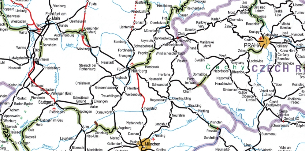
Image: a detail of the Thomas Cook Rail Map of Europe, 18th edition
Thomas Cook Rail Map of Europe
The most famous rail map is Thomas Cook’s Rail Map of Europe, which measures 100 x 70 cm and shows all of the main passenger railways of Europe; from Greece, Italy and Spain in the south, to lower Scandinavia, the Baltic States and part of Russia in the north. It depicts over 6,000 cities and towns, with colour-coding for high-speed lines (red) and scenic routes (green). The legend is in four languages.
The map also includes many ferry routes, which is especially handy if you are travelling around the Mediterranean or the Baltic Sea. On the reverse of the map is an enlargement of Central Europe, which focuses in more detail on the area from Paris in the west to Budapest in the east.
Published every two years, the latest is the 18th edition of the Rail Map of Europe, which was published in 2011. It was also the last. Thomas Cook abandoned its publishing business in July 2013. The publication of Thomas Cook’s rail timetable is continued by former members of the editorial team as the “European Rail Timetable”, but the rail map is not yet available.
The Rail Map of Europe includes the British Isles, but Thomas Cook also had a more detailed Rail Map of Britain and Ireland on offer. It, too, was published every two years, with the latest 7th edition being that of 2011. This map is for sale at the European Rail Timetable.
Kümmerly+Frey Railmap Europe
Although I find the Thomas Cook rail maps to be the most handy, the Railmap Europe from Swiss publisher Kümmerly+Frey (KuF) is a worthy alternative. It is almost twice as large as Thomas Cook’s Rail Map of Europe, but this extra space is not used to show more detail: the scale is 1 to 5 million, versus 1 to 4 million for Thomas Cook’s map. Rather, KuF’s Railmap Europe shows the railways in a wider geographical context.
Every single square kilometre of Europe is covered, including the upper parts of Scandinavia, which Thomas Cook doesn’t show. Furthermore, the map includes the railways of northern Africa, the Middle East, and Russia (as far east as Yekatarinburg). Curiously, about one-tenth of the whole map serves just to include Iceland, which has no railways.
An interesting feature is that Kümmerly+Frey’s Railmap Europe also shows the type of track (single or double, electrified or not, real or upgraded high speed line, cargo or passenger line, broad or narrow gauge). Thomas Cook distinghuises fewer types of track. On the other hand, KuF’s map does not show ferry routes, although it does depict train ferries (both for cargo and passengers trains). The map is sold folded or unfolded, and the legend is in 6 languages. KuF also publishes a national rail map of Germany.
Other Folded Rail Maps
There are more rail maps available, none of which I ever held in my hands. Quail Map Company publishes several rail maps of individual European countries: Portugal (3rd edition, 2010), Greece (2000), and Estonia (1997). American Publisher East View has a paper Rail Map of Europe, which is cheaper than most others but seems to be of lesser quality. It reportedly misses a large part of Eastern Europe.
Canadian publisher International Travel Maps sells a Europe Railways Map, which seems to be somewhere in between Thomas Cook’s and KuF’s products, although it also shows major roads and is printed on plastic paper. The Streetwise Europe Rail Map is printed on laminated paper, and has one half of Europe on each side. It is a very small map, the size of a sheet of paper, which shows very few details (the scale is 1 to 11.5 million). Lastly, there is also a Skirail map of the Alps.
Eisenbahnatlas EU
None of the rail maps described above show all train routes. Local railroads are only depicted in popular tourism areas, or not at all. The European network connects 30,000 cities, villages, and hamlets, while the Thomas Cook Rail Map of Europe only displays the rail links between one fifth of them.
There is one exception, however: the Eisenbahnatlas EU, published by Schweers+Wall in Germany in May 2013. As the name implies, this is not really a map but an atlas, which shows the European railway network in scale 1 to 2 million, twice the detail of the Thomas Cook map. It is a bit overkill for the average train traveller, who is problably not interested in the voltages and track width of every single rail line on the continent. The Eisenbahnatlas shows it all, including the location of marshalling yards and logistic stations.
Schweers+Wall also publishes the Eisenbahnatlas for individual countries. These have even more detailed maps, including subways, tramways, milestones, tunnels, crossovers, abandoned lines, and lots of technical information. The scale is 1 to 150.000 or 300,000 for general maps, and 1 to 50,000 or 100,000 for maps of railway hubs. The legend of the Eisenbahn atlases is in 4 languages. For now, half a dozen countries have their own Eisenbahnatlas: Germany (which is published since 1994), Austria, Switzerland, and Italy (which also includes Slovenia). The atlas for France is on its way.
European Railway Atlas
English publisher Ian Allan had a similar series called the “European Rail Atlas“, which was discontinued some years ago. They still publish a “Rail Atlas of Great Britain and Ireland” and a massive amount of other books on railroads.
M.G. Ball, the editor of the series, now publishes his own “European Railway Atlas“, as well as compact railway atlasses of individual European countries or regions (which are in fact all separate chapters from the European Railway Atlas). They are available both as A4 sized books and as Adobe Acrobat pdf files. All passenger, freight and proposed lines are shown, as are most heritage railways. Main lines are distinguished from secondary lines, and the same goes for single and multiple tracks. Electrification systems and track gauges are shown. Changes and corrections are listed on the website.
Oxford Publishing Company’s “Rail Atlas of Great Britain and Ireland” was first published in 1977. The thirteenth edition appeared in 2013. Great Britain is also the subject of the most detailed rail atlas available: the TRACKatlas of Mainland Britain. The maps show track level detail in a schematic format set over geographic centre lines. All stations appear with most signal boxes, junctions and tunnels including their names and railway mileages; most level crossings are included together with information describing their type.
Online Rail Maps
You can obtain a free rail map of Europe if you buy an InterRail or EuRail Pass, which gives you unlimited train travel in Europe for a certain period. It is a rather small (52 x 30 cm) but useful map, which can also be consulted online. The European Rail Guide has rail maps online, both for Europe as a whole and individual countries separately, and so have Raildude and All Europe Rail. There is also a large collection of national train maps to be found on this amateur website. While an online rail map sounds more modern, nothing beats the convenience of a printed map when you are planning a trip.
Rail maps are of little use in the US, where you can be happy to find one single route between two cities. Sadly, this also seems to be the future of the European rail system.
Kris De Decker (edited by David Fox)