The Fastest Sailboat in the World

fastest sailboat in the world

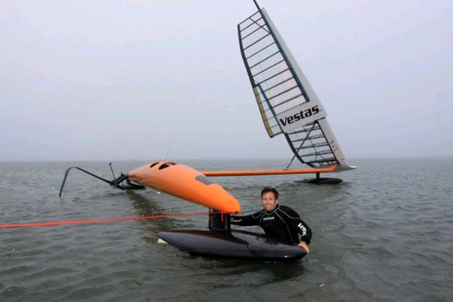
The Sailrocket, a sailing boat that we have talked about before, is the fastest craft under sail, after breaking the 2010 record held by a kiteboarder.

During the last run in Namibia in November 2012, an improved version of this unconventional boat reached an average speed of 65.45 knots (121.21 km/h or 75.31 mph) over a distance of 500 meters. Earlier this year it set speed records of 59.23 and 59.37 knots.

Record sailing speeds have almost tripled since the beginning of the 1970s. Those who think that sailboats are a technology from the past, think again.

See and read more at YachtPals and Sailrocket.

Making Bellows

making bellows

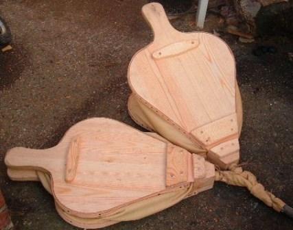
“This is hopefully the start of a set of documents that will help in the construction of a portable, authentic forge and bronze casting set up. I am starting with the bellows as I can use them at home to help get the fire going in the winter months.”

“I have repaired a number of sets of bellows, but this is the first set I have actually made myself from scratch. They appear to work well – good flow rate, nice range of movement, practically no air loss. If you follow any of the instructions below and it doesn’t work properly – well then you are just doing it wrong.”

Making bellows.

Building Plans for Dutch Industrial Windmills (1850)

building plans dutch sawmill

This collection of 21 building plans for 5 different types of Dutch industrial windmills was published in 1850. There is a saw mill, an oats mill, a flour mill, and two pumping mills. The book contains no text, only illustrations.

Theoretisch en practisch molenboek: voor ingenieurs, aannemers, molenaars en andere bouwkundigen“, G. Krook, 1850.

(“Theoretical and practical windmill book; for engineers, contractors and millwrights”).

[Read more…]

Sailing 10,000 Nautical Miles Using the Stars, Moon and Sun

Te-aurere-wakaA group of intrepid Māori sailors from New Zealand will take on the world’s biggest ocean, the Pacific, in an attempt to sail to Easter Island, the most remote inhabited place on Earth, without GPS, charts, maps, or even a compass.

Instead the group will be guided by the traditional techniques that helped the Polynesian people traverse the wide expanses of the Pacific and settle the islands of Hawaii, New Zealand and Tonga, to name just a few – techniques like the movement of the stars, the sun and moon, oceanic currents and bird and animal life.

The sailing odyssey is part of an effort by Polynesian academic and cultural groups to reclaim the navigational knowledge of their forebears, much of which was lost after European colonization.” Read more (official website). Previously: Polynesian stick charts / Satellite navigation in the 18th century / Developed nations dangerously over-reliant on GPS.

Trees as Indicators of Prevailing Wind Direction

trees as indicators of wind direction“In mountainous areas, winds are often complex and the available wind data are limited and provide little information on wind direction. One technique for determining the mean wind direction is tree flagging. Trees have been used for hundreds of years as an ecological indicator of wind direction, wind exposure and as a measure of the severity of wind and ice damage. This handbook will describe techniques for ‘reading’ the information written on the trees by wind.”

“Flagged trees only reflect the prevailing wind direction of the strongest winds, which may occur during only part of the year. Seasonal variations in the wind have a pronounced effect on the type of wind deformation and these effects are characterized in this handbook. Techniques for estimating the mean annual wind speed have been developed using indices of wind effects on trees. These indices have been calibrated on two widely distributed species of conifers. The main conclusions are that trees provide a simple, inexpensive and quick method for identifying promising locations where more detailed measurements can verify the wind potential.”

Trees as an indicator of wind power potential (.pdf), John E. Wade & E. Wendell Hewson, 1979.
Vegetation as an indicator of high wind velocity (.pdf), DOE report, John E. Wade & R.W. Baker, 1977

More low-tech wind power.

The Junk Blue Book: Indigenous Fishing and Cargo Craft

Vietnamese junk qtbc 1 “The Junk Blue Book of 1962 is a detailed catalog of the indigenous boats of what was then South Vietnam, during a period when most such vessels were still powered by sail. It was a manual put together by the US Dept. of Defense early in the involvement in the war in Vietnam. It was used as a guide to identify coastwise marine traffic involved in smuggling supplies and personnel south into the Republic of Vietnam from then North Vietnam. Although its production was driven by perceived military necessity it is a unique chronicle of the indigenous fishing and cargo craft of the mid and southern Vietnamese coasts.”

The book is in the public domain and can be found on scribd. A pdf-version is available on a dedicated site. Via Indigenous boats. See also: the wooden work boats of Indochina.