The Atlas of Environmental Justice

atlas of environmental justice

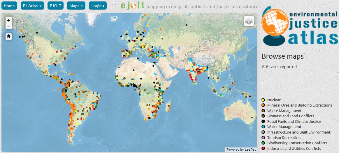
“Across the world communities are struggling to defend their livelihoods from damaging environmental impacts. Mining projects, mega dams, tree plantations, fracking, gas flaring, incinerators, etc … As resources needed to fuel our economy move through the commodity chain from extraction, processing and disposal, environmental impacts are externalized onto the most marginalized populations. But all this takes place far from the eyes of the consumers of the end-products. The Environmental Justic atlas aims to make these impacts more visible and to make the case for true corporate and state accountability for the injustices inflicted through their activities.”

“The map tells a story of environmental devastation and despoliation, of ecocide and eco-apartheid, but also a story of resistance, and communities mobilizing to fight against the odds. Of the cases currently in the map, 17% are successes for environmental justice. Court cases were won, communities were strengthened, and access to the commons was reclaimed. These victories are a testament to the power of protest and the ability to impact the political process. We don’t aim to “solve” the conflicts but to reveal the actors and drivers and structural patterns behind them. The defense of territory, the defense of livelihood and the defense of the resources that communities depend on are the best weapon against endless capitalist exploitation of the ecological system we depend on.”

The Atlas of Environmental Justice.

The Complete Guide to European Rail Maps & Atlasses

We all know road maps, but few people are aware there also exists such a thing as a rail map. Why would you need a rail map? After all, you are not steering and the train driver knows the way. However, a rail map gives you control over the route you take. In Europe, there are many ways to travel by rail from A to B. If you order a train ticket from Amsterdam to Madrid, for example, the train company will not necessarily offer you the cheapest or most interesting route.

rail map of europe

A rail map is especially interesting if you want to avoid high speed trains (which are more expensive), if you make long-distance trips, or if you just love to marvel at spectacular scenery. While an online rail map sounds more modern, nothing beats the convenience of a printed map when you are planning a trip.

[Read more…]

Why the Brain Prefers to Read on Paper

“Beyond treating individual letters as physical objects, the human brain may also perceive a text in its entirety as a kind of physical landscape. When we read, we construct a mental representation of the text in which meaning is anchored to structure. The exact nature of such representations remains unclear, but they are likely similar to the mental maps we create of terrain—such as mountains and trails—and of man-made physical spaces, such as apartments and offices.

book 4Both anecdotally and in published studies, people report that when trying to locate a particular piece of written information they often remember where in the text it appeared. We might recall that we passed the red farmhouse near the start of the trail before we started climbing uphill through the forest; in a similar way, we remember that we read about Mr. Darcy rebuffing Elizabeth Bennett on the bottom of the left-hand page in one of the earlier chapters.

In most cases, paper books have more obvious topography than onscreen text. An open paperback presents a reader with two clearly defined domains—the left and right pages—and a total of eight corners with which to orient oneself. A reader can focus on a single page of a paper book without losing sight of the whole text: one can see where the book begins and ends and where one page is in relation to those borders. One can even feel the thickness of the pages read in one hand and pages to be read in the other.

Turning the pages of a paper book is like leaving one footprint after another on the trail—there’s a rhythm to it and a visible record of how far one has traveled. All these features not only make text in a paper book easily navigable, they also make it easier to form a coherent mental map of the text.”

Read more: The Reading Brain in the Digital Age. Picture: This is a Wake Up Call. More books.

The European Railways Network 1870 – 2000

These five maps, based on GIS data and made by the Department of Geography and Sociology of the University of Lleida (Spain), show the evolution of the European railways infrastructure in the 19th and 20th centuries.

[Read more…]

Developed nations dangerously over-reliant on GPS

Developed nations dangerously over-reliant on GPS

“As technologies become easier to use and more cost effective their use can become almost ubiquitous. If they present a more convenient solution to an old problem, they can usurp older technologies very quickly, forcing obsolescence on otherwise excellent technologies and taking a dominant position. The use of Global Navigation Satellite Systems (GNSS) for deriving position, navigation and timing (PNT) data is such a case. The Global Positioning System (GPS) is currently the most widely used and best known example of GNSS.”

“Today, the relative ease of use of GPS in-car navigation systems means that many motorists rely entirely on GPS for navigation and if they have a road map as a back-up, it is not likely to have been used or updated in a long time. This is a trivial example of reliance on GPS with neglect of back-up systems, but the use of GPS signals is now commonplace in data networks, financial systems, shipping and air transport systems, agriculture, railways and emergency services. Safety of life applications are becoming more common.”

“One consequence is that a surprising number of different systems already have GPS as a shared dependency, so a failure of the GPS signal could cause the simultaneous failure of many services that are probably expected to be independent of each other.”

Global Navigation Space Systems: reliance and vulnerabilities (pdf). Summary.

Hand-crafted Maps

Anglo-Saxon-map-being-drawn-300x224 “Over the past year, we’ve been publishing hand-crafted maps of various bits of London, drawn by readers. You can view the complete set of entries here, including Brixton as a tree, and this beauty. Now, we’re delighted to say that the Museum of London will be running an exhibition of the best hand-drawn maps, from 21 April next year. That’s still a long way off, so there’s time for new submissions. If you’d like to be considered for inclusion in the exhibition (and be featured on Londonist), simply send us a doodle of your local neighbourhood, the area you work in, or some random part of town that deserves more attention.”

Read, via The Map Room.